
Objective
Renewable energy is a rapidly growing industry in the United States, and we will only rely on it more over time. Wind energy collected by turbines is a wonderful example of a green source of energy that can help America move towards a sustainable future. In order to make this dream a reality, our country must meticulously plan where we can place wind farms. We can use data science to determine how many wind turbines we can fit into certain plots of land while taking urban structures and natural protected spaces into account.
In particular, the state of Iowa has ideal environmental conditions for wind farms with its flat landscape and high, consistent wind speeds. This project aims to evaluate the maximum potential annual wind energy production available to the state of Iowa (meaning the quantity of megawatt hours that would be generated by placing as many 3.45 MW wind turbines as possible on all appropriate sites).
Approach
This will be executed by first identifying all land suitable for wind turbine placement, subject to the siting constraints using Python, SQL, and PostGIS/OpenStreetMap. Subsequently, the area of each polygon suitable for wind production can be calculated, along with the number of wind turbines that could be placed in each polygon based on the minimum distance that they need to be from one another. This information will then be used to calculate the total annual energy production that would be realized by the maximum possible number of new turbines.
We will be hypothetically using Vestas V136-3.45 MW turbines, which have a 150m hub height.
Load Packages & Import Data
Our goal is to apply queries to a PostGIS database that contains
Iowa’s feature data from OpenStreetMap. In order to connect our Jupyter
Notebook to the PostGIS database, we use the package
sqlalchemy.
import sqlalchemy as sa
import geopandas as gpd
import numpy as np
import pandas as pd
import math
PostGIS Database Connection:
pg_uri_template = 'postgresql+psycopg2://{user}:{pwd}@{host}/{db_name}'
db_uri = pg_uri_template.format(user='eds223_students', pwd='eds223', host='128.111.89.111', db_name='osmiowa')
engine = sa.create_engine(db_uri)
There are multiple tables in this engine. Shapefiles can take the form of points, lines, or polygons, and we need to query each of these types separately, so we need three separate PostGIS “connections”.
osm_polygons = gpd.read_postgis('SELECT * FROM planet_osm_polygon', con = engine, geom_col = 'way')
osm_lines = gpd.read_postgis('SELECT * FROM planet_osm_line', con = engine, geom_col = 'way')
osm_points = gpd.read_postgis('SELECT * FROM planet_osm_point', con = engine, geom_col = 'way')
# we use the column "way" because that is the title of the geometry column in this database
We also need to make a separate connection to the database to pull in the wind speed data for each geometry, which we will utilize at the end of our querying in order to calculate the wind power production:
osm_wind = gpd.read_postgis('SELECT * FROM wind_cells_10000', con = engine, geom_col = 'geom')Queries for Siting Constraints
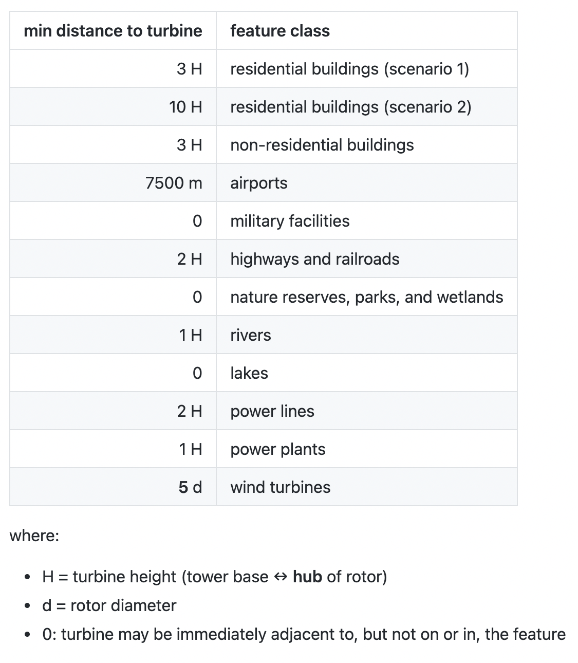
One cannot legally place wind turbines anywhere they please within the state of Iowa; there are restrictions in place that create restricted buffer zones around homes, airports, protected natural areas, and more. We need to adhere to these restrictions, only considering residential buildings buffer scenario 1:
 Define important variables that
you will utilize within the queries:
Define important variables that
you will utilize within the queries:
# H = turbine height (tower base ↔ tip of vertical rotor), in meters
H = 150
# this value can be found on the website for Vestas wind turbines, linked above

# distance required from airports, in meters
aero_dist = 7500

# d = rotor diameter, in meters
d = 136
# this value can be found on the website for Vestas wind turbines, linked above
Subqueries
Separate queries are necessary for each feature, as each requires a
different buffer zone around their geometries. We assign these SQL
queries to Python objects, then we will combine them in the next step.
We use the syntax f""" with triple quotes so we can format
the code within the quotes with variables and line breaks for vertical
organization.
# use scenario 1 with 3*H serving as the required distance
sql_buildings_residential = f"""SELECT osm_id, building, landuse, aeroway, military, highway, railway, leisure, "natural",
water, waterway,
ST_BUFFER(way, 3 * {H}) as way
FROM planet_osm_polygon
WHERE building IN ('yes', 'residential', 'apartments', 'house', 'static_caravan', 'detached')
OR landuse = 'residential'
OR place = 'town'"""

sql_buildings_non_residential = f"""SELECT osm_id, building, landuse, aeroway, military, highway, railway, leisure, "natural",
water, waterway,
ST_BUFFER(way, (3 * {H})) as way
FROM planet_osm_polygon
WHERE building NOT IN ('residential', 'apartments', 'house', 'static_caravan', 'detached')"""

sql_aeroway = f"""SELECT osm_id, building, landuse, aeroway, military, highway, railway, leisure, "natural",
water, waterway,
ST_BUFFER(way, {aero_dist}) as way
FROM planet_osm_polygon
WHERE aeroway IS NOT NULL"""

sql_military = f"""SELECT osm_id, building, landuse, aeroway, military, highway, railway, leisure, "natural",
water, waterway, way
FROM planet_osm_polygon
WHERE (landuse = 'military')
OR military IS NOT NULL"""

sql_highway = f"""SELECT osm_id, building, landuse, aeroway, military, highway, railway, leisure, "natural",
water, waterway,
ST_BUFFER(way, (2 * {H})) as way
FROM planet_osm_line
WHERE (railway NOT IN ('abandoned', 'disused'))
OR highway IN ('motorway', 'trunk', 'primary', 'seconday', 'primary_link', 'second'"""

sql_leisure = f"""SELECT osm_id, building, landuse, aeroway, military, highway, railway, leisure, "natural",
water, waterway, way
FROM planet_osm_polygon
WHERE leisure IS NOT NULL
OR "natural" IS NOT NULL"""

sql_river = f"""SELECT osm_id, building, landuse, aeroway, military, highway, railway, leisure, "natural",
water, waterway,
ST_BUFFER(way, (1 * {H})) as way
FROM planet_osm_line
WHERE waterway IS NOT NULL"""

sql_lake = f"""SELECT osm_id, building, landuse, aeroway, military, highway, railway, leisure, "natural",
water, waterway, way
FROM planet_osm_polygon
WHERE water IS NOT NULL"""

sql_power_lines = f"""SELECT osm_id, building, landuse, aeroway, military, highway, railway, leisure, "natural",
water, waterway,
ST_BUFFER(way, (2 * {H})) as way
FROM planet_osm_line
WHERE power IS NOT NULL"""

sql_power_plants = f"""SELECT osm_id, building, landuse, aeroway, military, highway, railway, leisure, "natural",
water, waterway,
ST_BUFFER(way, (1 * {H})) as way
FROM planet_osm_polygon
WHERE power IS NOT NULL"""

sql_wind_turbines = f"""SELECT osm_id, building, landuse, aeroway, military, highway, railway, leisure, "natural",
water, waterway,
ST_BUFFER(way, (5 * {d})) as way
FROM planet_osm_point
WHERE "generator:source" IS NOT NULL"""
Mega-Query
Combine the subqueries into one mega-query so we can subtract all these restricted geometries as one unit. These subtracted geometries can be considered a “mask” in spatial data science jargon.
mask_1 = f"""{sql_buildings_residential}
UNION
{sql_buildings_non_residential}
UNION
{sql_aeroway}
UNION
{sql_military}
UNION
{sql_highway}
UNION
{sql_leisure}
UNION
{sql_river}
UNION
{sql_lake}
UNION
{sql_power_lines}
UNION
{sql_power_plants}
UNION
{sql_wind_turbines}"""

mask_1_df = gpd.read_postgis(mask_1, con = db_uri, geom_col = 'way')

# take a look at the state of Iowa without this "mask" of geometries
mask_1_df.plot()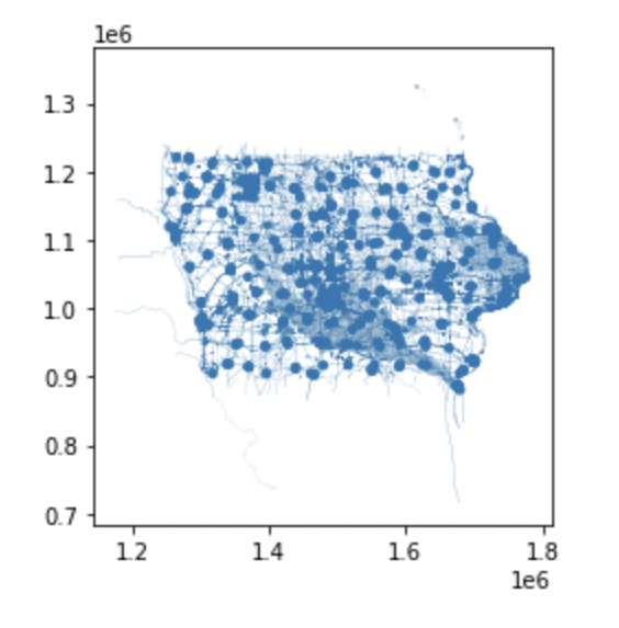
Wind Data
Subtract the union of the string constraints from the wind cells so we are left with only those (fractions of) cells that could accommodate new wind turbines. These are “suitable cells”.
suitable_cells_1 = osm_wind.overlay(mask_1_df, how = 'difference')

#Find area of each suitable cell/geom in the database
suitable_cells_1['suitable_cell_area'] = suitable_cells_1.geom.area
Now we can calculate the area of the turbine footprint as a circle with a radius of 5 rotor diameters, with the goal of calculating a scenario in which turbine towers must be at least 10 rotor diameters apart.
Calculate a buffer circle around each wind turbine, called a “turbine footprint”.
turbine_footprint = math.pi*((5*d)**2)Calculate the number of wind turbines that could be placed in each polygon, by dividing each suitable cell by the turbine footprint.
suitable_cells_1['n_turbines'] = suitable_cells_1['suitable_cell_area'] / turbine_footprintCalculate the total wind energy produced per cell by multiplying the amount of turbines in each suitable cell by the annual wind production for each turbine.
Formula:
E = 2.6 s m-1 v + -5
GWh
E = energy production per turbine in GWh
v = average annual wind speed in m s-1
suitable_cells_1['energy_prod_per_cell'] = suitable_cells_1['n_turbines'] * ((2.6 * suitable_cells_1['wind_speed']) - 5)Results
Sum the energy production over all the cells into a single statewide number for residential exclusion distance scenario 1.
total_energy_product_1 = sum(suitable_cells_1['energy_prod_per_cell'])The maximum annual potential wind energy production available to the state of Iowa is 1036574.26 GWh.
Please feel free to reach out with any similar applications for this notebook, and I welcome all questions and suggestions about my code. May the wind empower us to continue to study sustainable energy through the lens fo data science!
Acknowledgements
I would like to thank my collaborator on this project, Sydney Rilum from the Bren School of Environmental Science and Management, for her contributions. I will always remember the excessive amount of time we spent drawing wind turbine circles on scratch paper and adjusting the mathematical calculations to reflect different rotor diameters and how that changes the wind power potential for the state of Iowa.
Thank you, Dr. James Frew and Niklas Griessbaum from the Bren School of Environmental Science and Management, for prompting us to investigate this question. Your expertise in spatial data science has inspired me to answer more questions like this in my future career.